Posts for this topic...
-
Post your comments.... Sign In to Post
-
plotaroute admin Saturday 15 Nov 2014 11:37:03
We are very excited to announce the launch of another major new feature on plotaroute.com - the Route Profile Tool.
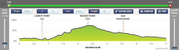
The new Route Profile Tool gives you a detailed analysis of the elevation profile for your route, with options to download, print and share the profile chart and the underlying elevation data. A comprehensive range of sliders and buttons give your control over the way the route profile is calculated and plotted, with options to filter out short bumps and to smooth the profile by sampling elevation readings less frequently. Detailed analysis of sections of the route is easy to do using the Section Selector slider and you can resize the map and chart panels to get a close up of the information you want.
Labels can be added to the chart to show key points along the route like the highest point or longest uphill section and you can even add your own custom labels - for example, showing water stations if your route profile is for an event.
It easy to share your route profile with our social sharing buttons and you can download it to an image or PDF file, for use on your own website or printed material if you wish. Or you can simply share a direct link to the Route Profile Tool with your chosen settings.
There are various links to the new Route Profile Tool thoughout plotaroute.com, including the main Route Information page for each route. Look for this link: Route Profile Tool. Just one final note, if you are plotting a new route you will need to save it first to view it in the Route Profile Tool.
To see an example have a look at the route profile for East Quantoxhead Coastal Circuit.
Have fun checking out those hills!
Update : We've just added support for vertical labels on the route profile chart and have fixed a few bugs that we've picked up.
-
Whitney Pugh Saturday 15 Nov 2014 15:57:28
2 questions in general because I don't know where to submit suggestions/questions:
1) your maps don't seem to include a direction arrow indicating north. why?
2) your distance measures are awesome, but there are no bearings for orienteering! If we're hiking, and need a compass with the map we design, bearings would be so helpful, and it seems like it ought to be easy for you to add that feature
-
bilies lerg Saturday 15 Nov 2014 23:28:53
i really appreciate your effort and time to create all these powerfull tools. This is a website with real potential, i love it and i use it in a daily basis! I noticed that the iphone interface came a long way, i just love it!
thanks again!
-
plotaroute admin Sunday 16 Nov 2014 07:26:02
Thanks Sandu - that's fantastic feedback, much appreciated.
Whitney - I see you've posted you questions in our 'Feature Requests' Forum as well, so I'll answer them there.
John
-
Deleted User Friday 23 Jan 2015 15:29:06
I have two suggestions for the route profile tool. First, it would be helpful if the map and the elevation profile were linked, so if you hover the mouse over the route in the map, you'd see the tool-tip move around at the right location in the elevation profile. Alternatively if you hover the pointer in the elevation profile, a dot would move around in the map corresponding to the same point along the route.
Second, it would be helpful to limit the extents of the elevation axis, so instead of the lower bound being 0 ft, the user could set it to be anywhere between 0 and the minimum elevation in the route.
Thanks for the site!
-
plotaroute admin Friday 23 Jan 2015 17:12:03
Great suggestions - thanks. I don't think they should be too difficult, so we'll see what we can do.
John
-
plotaroute admin Friday 23 Jan 2015 21:24:10
I'm pleased to say that we've been able to implement these suggestions straight away :-) We've also added a new search box at the top of the Route Profile page so you can easily switch to other routes. Thanks again for putting these ideas forward.
John
-
Deleted User Monday 26 Jan 2015 20:44:21
Thanks!
I think there's a bug on the minimum elevation slider. When I try to set the min elevation to 449 feet, it only sets it to about 130 in the graph. I suspect it's a units thing (449 feet = 137 m).
-
Deleted User Tuesday 27 Jan 2015 13:06:20
I also just noticed that now the plot of the elevation profile gradient no longer shows negative values (it starts at 0).
-
plotaroute admin Tuesday 27 Jan 2015 17:00:48
Thanks for flagging these up - we didn't spot these during testing. We'll get them fixed as soon as possible.
John

