Posts for this topic...
-
Post your comments.... Sign In to Post
-
plotaroute admin Thursday 26 Nov 2015 16:45:07
We are pleased to announce that today we have introduced a brand new option to be able to download route maps as images, in JPG, GIF or PNG formats. The downloaded images use open source maps, so you can use and distribute them freely without any copyright concerns, provided they are not modified - great for use on blogs, event websites, social networks and printed media.
It's very easy to download route maps in recommdened formats and sizes for use on Facebook and Twitter or you can choose a custom format and size up to 2000 x 2000 pixels. If you've saved your route with public access, you could also link the image to an interactive version of your route on plotaroute.com.
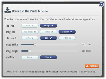
To access this new feature, select DOWNLOAD from the menu when viewing a route or D'LOAD from the action panel on the map when editing a route. This new feature is also available on our mobile site, so you can also download route images and save then to your phone's photo albums for use with other apps.
Don't forget, if you want to put a route map from plotaroute.com on your own website, you also have the option of embedding a Video Map of your route if you prefer this rather than a static image.
-
Tim Wason Saturday 05 Dec 2015 22:26:17
This was wonderful. For a permit agency I needed a way to give them an image, and this worked wonderfully. Rather proud of myself that I figured it out before I read the notice of the feature change, which indicates again that your app is simple, intuitive, and it works!
Your program is so much easier to use than anything else I have found, and I have looked pretty hard. Maybe it's just becasue it's English ;).
I organize running races, next Sunday it's my really big one, the USA Track & Field National Club Cross Country Championships in Golden Gate Park in SF. You had a hand in the Championships!
Would love if the route on the map reflected how hilly it was at that point, so you could tour the thing and see the route changing as it goes up and down hill, not necessarily a separte elevation map. That would be super for XC and everything else. Like others, would like to change colors of the route on the map, say for different miles. As a race director, being able to put in prosaic stuff like portable toilets, canopies, tables and the like would also be wonderful, labeling those things would be nice too.
Thanks. Give me an address and I will see if I can round up some swag as a souvenir for your work. (Doing this for other events might be a fun little hobby, and a great advertising picture to put on the site-- "Here's who's using us").
USA Track and Field has a mapping program at their site, but I would pick yours anyday over that one. Look at it at:
http://www.usatf.org/routes/ Note there are well over 500,000 routes in there... Uses Google maps like everyone else.
-
plotaroute admin Sunday 06 Dec 2015 09:22:08
Thanks for wonderful feedback Tim. It's always great to hear that people are finding new features useful and easy to use. Thanks for the offer of the 'swag bag'! I'll email you separately with an address.
Hopefully we can add more features for race directors like yourself. There may be one or two features that already exist that might be useful to you. We don't have a way of showing elevation on the map at present but it is possible to view the elevation profile together with the map and see the corresponding positions on the route map and elevation profile - select "Hills" when viewing or editing a route on the site. You can also download the route as a KML file and open it in Google Earth, enabling you to 'fly-over' the route in 3D, which I think might be more what you are looking for.
We also have an option to add symbols to a map (e.g. toilets). You can do this by adding them to directions/notes in the route planner (select "DIR'NS" from the list of options on the map). These will be displayed when people view the map on the site but are not yet available when downloading a route map as an image - we can look at extending that to downloaded maps if it would be useful. We don't currently have a way of adding text labels on to a map but it is on our Feature Request list and something we hope to be able to look into fairly soon.
That's a great idea to add an "as used by...." section to the site. I'll have a look into this.
Thanks again.
John

- 1
