Posts for this topic...
-
Post your comments.... Sign In to Post
-
plotaroute admin Sunday 21 Dec 2014 16:28:08
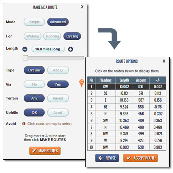 We're pleased to announce another upgrade of our popular Make Me a Route feature, which automatically generates routes of a specified length from a given start point. This latest release introduces the option of specifying a 'via point'. So, for example, it might be a café where you want to stop for refreshments or simply a point on the map in the general direction that you want to head.
The addition of this new option takes the Make Me a Route feature to a whole new level - previously if you asked for circular routes of a specified length from a given start point you would get the same suggestions each time, but now, with the ability to choose a different mid-way point to go via, you can get a different set of suggestions each time by just choosing a different via point. And you can now specify an additional waypoint when generating A to B routes too, giving you even more new options for routes.
As part of this upgrade we've also made a few other minor improvements, including a new Crow-Flies Distance counter, so you can get a rough idea of the distance when choosing where to place the waypoints for your auto-generated routes.
To get started, select Make Me a Route from the Plot menu in the route planner or take a look at our newly updated Make Me a Route Video Tutorial.
Have fun making routes!
-
Alan Gaskell Tuesday 13 Jan 2015 20:58:04
I find your route planning tool the most intuitive and best of the bunch I have tried, and by default use it to plan my routes. I would like to use the Make Me a Route tool but in spite of setting defaults as road and paved, the routes frequently incorporate paths. I want to stick to roads only. Is there a way of setting this?
-
plotaroute admin Wednesday 14 Jan 2015 08:33:30
Hi Alan - Thanks for your kind feedback about the site.
Can you give me an example of the issue with the roads/paths please - i.e. what start point and other settings you are using - and I'll have a look into this?
John
-
Alan Gaskell Friday 16 Jan 2015 08:46:08
Hi John. I have made this route, which I am pasting below, and hope this works! If not it is under shared routes, title "Test Plot Me a Route". The section from 2 to 3 passes through a private golf club (and although I have not taken the route, I am surprised that there is a connection!) but where there is definitely no road is from 3 to 5 across Ashtead Common.
The settings I used are cycling, paved roads, hills. You can see that my start and finish point is on a paved road.
Thanks
Alan
-
plotaroute admin Sunday 18 Jan 2015 11:21:12
Hi Alan - I've had a look a this and I can see where it goes across Ashtead Common (Bridleway 29). Unfortuantely we are a bit limited by the data provided by the routing services we use and I think this must be mistakenly marked down as a paved path on their database.
The best way to ensure that this path isn't used on the routes being generated is to add it to the "Avoid" list. You can do this by clicking on the path on the map - a red block symbol will be placed there and the route generator will avoid going through this point. I placed a block at the western end of Brideweay 29 and this seemed to solve the problem.
Hope this helps.
John
-
Alan Gaskell Tuesday 20 Jan 2015 22:38:33
Thanks John. I realise that adding avoid helps but I have come across a number of these type of issues which makes this wonderful feature frustrating to use if the route is a new unknown one. I will try out your suggestion but I think that I will have to stick to making my own routes!
Regards
Alan
-
maggie strudwick Thursday 10 Oct 2019 17:33:59
Hi
I am new to Plotaroute and have been planning a walk in New Ash Green and Ash (Kent). There are public footpaths en-route signposted (county council paths), yet they do not show on the maps. Also where there are some paths, the plotter does bot recognise them and puts in a road route. I have checked that I am on mixed routes. Is there a way to plot on land that does not show an existing footpatth?
Thank you
-
plotaroute admin Friday 11 Oct 2019 08:10:44
You can plot anywhere on the map by turning off the Auto-Plot switch.
 We're pleased to announce another upgrade of our popular Make Me a Route feature, which automatically generates routes of a specified length from a given start point. This latest release introduces the option of specifying a 'via point'. So, for example, it might be a café where you want to stop for refreshments or simply a point on the map in the general direction that you want to head.
- 1
