Posts for this topic...
-
Post your comments.... Sign In to Post
-
Mark Hedger Monday 25 Mar 2024 21:57:12
I've managed to view the fly over but the routes are very pixilated, is this the norm? Am I expecting too much? Thanks
-
plotaroute admin Tuesday 02 Feb 2016 09:18:57
We don't have our own navigation app yet but when you view a route from plotaroute.com on a mobile device you can track your position on the map (press the tracker icon in the bottom right corner) to toggle tracking on and off. There are also several 3rd party navigation apps in the app stores, which can accept route downloads from plotaoroute.com in TCX or GPX format. This post mentions OsmAnd an example for Android phones and for the iPhone CoRider is one example.
John
-
Alain Boucher Tuesday 02 Feb 2016 00:48:21
Can you actually follow a route from your mobile devise ans how ?
I want to place all the routes from my bike club into links that people can open and download to thier mobile. I have a GARMIN EDGE 800 and it works great.
But I want other poeple that do not have a GARMIN still use their mobile, so they don t gey lost !
-
plotaroute admin Wednesday 22 Jan 2014 00:00:00
How To View Routes in Google Earth
You can view your routes in glorious 3D using Google Earth. There are two ways to do this.
Option 1 - Use the Google Earth Browser Plugin
Download and install the Google Earth Browser Plugin.
After installing the plugin, you should see a new map type option in the top right corner of the map called "Earth". Select this to view your route in Google Earth in your browser.
Option 2 - Use Google Earth software
- Download and install Google Earth.
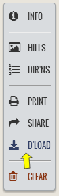
- To view your route in Google Earth, first click the Download icon in the action bar:
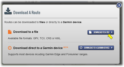
- Then select Download to a file:
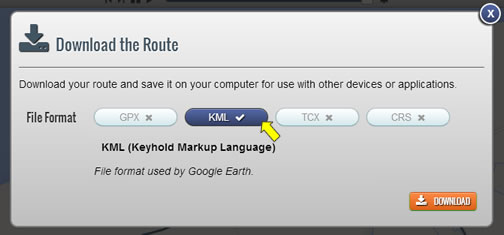
- Then select KML as the download file format:
- Once the file has downloaded, simply click on it to open the route in Google Earth.
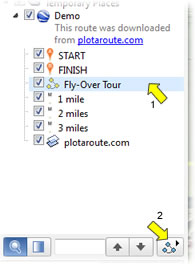
- You can view an animated Fly-Over the route by clciking on the 'Fly-Over Tour' item in the left panel (arrow 1 below) and then clicking the Play Tour button (arrow 2 below).
- Download and install Google Earth.


- 1
